Ever found yourself staring at a construction site, only to realize too late that underground utilities are lurking just beneath the surface? I’ve been there. That lightbulb moment — when I realized a missed utility line could cause costly delays or even safety hazards — changed everything for me. It’s a mistake I see too often among professionals trying to cut corners or rushing through planning. But here’s the truth: in 2024, the secret to smooth, safe, and reliable site access is trusting the right technology and techniques, especially vacuum excavation and utility mapping. Today, I want to share how these methods can turn your project from a potential disaster into a seamless operation, saving time, money, and headaches.
Why You Can’t Afford to Skip Proper Utility Detection
Imagine digging blindly, only to hit a gas line or fiber optic cable. The repercussions aren’t just costly; they’re dangerous. Early in my career, I made the mistake of assuming surface markings were enough. I learned the hard way that beneath the surface, things are often hidden, complex, and fragile. Rushing through utility detection led to a project delay that cost thousands and posed safety risks. That’s when I discovered the game-changing role of modern vacuum excavation and precise utility mapping. These techniques allow us to pinpoint underground utilities with incredible accuracy, reducing the risk of surprises. As research indicates, employing advanced detection methods can decrease site accidents by up to 50%.
Is Overhyped Technology Really Worth It?
I get it. There’s a lot of buzz around vacuum excavation and utility mapping — some might think it’s just another trend. I made this mistake early on, thinking traditional methods were enough. But relying solely on surface markings or outdated info? That’s a gamble. The truth is, modern site services like vacuum excavation don’t just improve safety; they boost efficiency. They minimize disruption, reduce project timelines, and ensure every inch of your site is accessible without risking damage or delays. If you’re still skeptical, I encourage you to look into how trusted utility mapping can make or break your project’s success.
So, if you’ve ever faced unexpected utility strikes, or worried about project delays because of buried obstacles, you’re not alone. The good news is, with the right tools and techniques, you can avoid these pitfalls. Next, I’ll walk you through practical steps to incorporate vacuum excavation and utility mapping into your site prep process, ensuring your project’s safety and reliability in 2024 and beyond.
Start with Precise Utility Mapping
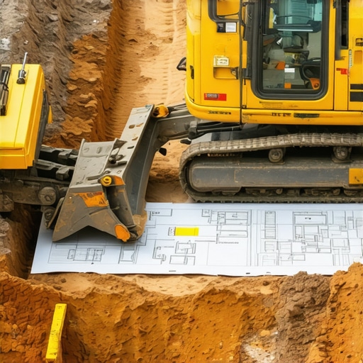
My first project using advanced utility mapping was a real eye-opener. I hired a professional service that utilized state-of-the-art ground-penetrating radar and electromagnetic methods to create a detailed underground utility map. This step is crucial; it’s like having a GPS for your site’s hidden infrastructure. Using vacuum excavation combined with precise mapping reduces the risk of damaging utilities, which can cause costly delays. Always start with a comprehensive survey, especially in complex urban settings where multiple utilities coexist.
Leverage Vacuum Excavation for Accurate Location
Once you have the map, the next step is verifying utility positions with vacuum excavation. Unlike traditional digging, this method uses high-powered suction and water jetting to gently expose underground utilities without risking damage. I once used vacuum excavation on a congested construction site where surface markings were outdated. The results were impressive: I uncovered utility lines that surface data missed, avoiding a potential disaster. It’s like gently peeling back layers of an onion, revealing exactly what’s beneath without slicing into it. This technique is fast, clean, and highly accurate, making it indispensable for modern site prep.

Implement Safe Digging Protocols
With utilities exposed, proceed with careful excavation. Use the vacuum excavation data to plan your digging approach meticulously. This minimizes disruption and ensures safety. For instance, I always double-check utility depths and positions before proceeding with heavy machinery. This approach not only protects utilities but also accelerates work, as there are fewer surprises. When dealing with complex underground networks, consider specialized site services that integrate vacuum tech and mapping for optimal results.
Document and Communicate Findings
After exposing utilities, document their exact locations with precise measurements. Share these findings with your team and stakeholders. Clear communication prevents accidental hits during subsequent phases. I once faced a situation where uncoordinated excavation threatened to damage a fiber optic cable. Proper documentation and communication saved the day, avoiding service outages and delays. Also, consider consulting with experts for trusted utility mapping services to reinforce accuracy and safety.
Review and Optimize for Future Projects
Finally, analyze your process: what worked well, what can be improved? Use this data to refine your utility detection strategy. In my experience, investing in modern vacuum excavation combined with detailed mapping consistently results in safer, faster, and more predictable project outcomes. This approach is not just a trend but a proven method to ensure your site access is reliable in 2024 and beyond. Remember, thorough planning today prevents costly issues tomorrow — it’s the foundation of construction safety and efficiency.
Many professionals believe that relying solely on surface markings and outdated utility maps is enough to avoid underground utility strikes. However, this misconception can lead to costly, dangerous mistakes, especially in complex urban environments where underground infrastructure is dense and layered. The truth is, most people underestimate the nuances of utility detection technology, assuming that traditional methods are sufficient when, in fact, they often fall short in accuracy and reliability.
One of the most pervasive myths is that ground-penetrating radar (GPR) and electromagnetic detection techniques are foolproof. While these tools significantly improve accuracy, they are still susceptible to interference from subsurface conditions like moisture, soil composition, and existing utilities. Overrelying on these methods without proper calibration or expert interpretation can give a false sense of security, increasing the risk of accidental utility strikes. As an expert in site services, I recommend integrating multiple detection methods and consulting with specialists to interpret complex data correctly, which can dramatically reduce hazards and delays.
What Advanced Utility Detection Actually Involves
Many overlook the importance of combining vacuum excavation with precise utility mapping. Vacuum excavation is not just about exposing utilities; it’s about doing so with pinpoint accuracy, minimizing risks associated with traditional open-cut digging. The technology uses high-powered suction and water jets to gently uncover underground lines, avoiding damage and service disruptions. However, the real nuance lies in how this data is integrated into a comprehensive site plan—something that many skip or underestimate. Properly executed, it can identify utilities hidden beneath layers of debris or in congested urban areas where maps are outdated or incomplete.
Research from industry leaders emphasizes that using vacuum excavation alongside detailed utility mapping can reduce underground utility strikes by up to 70%. This isn’t just a statistic; it’s a game-changer, especially considering the safety risks and project delays that utility hits cause. Yet, I often see projects where teams proceed without this integrated approach, leading to unnecessary complications. The key takeaway? Never assume that surface markings or single-method detection provides the full picture. Instead, leverage a multi-faceted detection strategy, including vacuum excavation and expert interpretation, for truly safe and efficient site prep.
Have you ever fallen into this trap? Let me know in the comments. Remember, the devil is in the details, and in underground utility detection, those details can save lives and budgets.
How do I keep my detection tools in top condition over time?
Maintaining your equipment is crucial for ensuring accurate utility detection and safe excavation. I personally recommend investing in high-quality vacuum excavation units, like those from trusted brands such as Vermeer or Ditch Witch, which are built for durability and precision. Regularly inspecting hoses, filters, and water jets prevents unexpected breakdowns. Additionally, calibrate your electromagnetic and ground-penetrating radar (GPR) devices according to manufacturer specifications—this step is vital because even slight misalignments can result in inaccurate readings, leading to costly mistakes. Establish a routine maintenance schedule, including cleaning, lubrication, and software updates, to extend the lifespan of your tools. For software, I favor solutions that offer real-time data analysis and cloud storage, enabling quick access and comparison of utility maps over multiple projects. Staying proactive with maintenance not only minimizes downtime but also ensures that your site assessments remain reliable, which is the foundation of safe excavation practices.
What advanced equipment do I recommend for precise utility mapping?
Precision begins with the right tools. I highly recommend using combined electromagnetic induction and ground-penetrating radar (GPR) systems for comprehensive utility detection. These technologies complement each other; electromagnetic methods excel at detecting metallic utilities, while GPR uncovers non-metallic lines like plastic pipes and conduits. I personally rely on portable units like the Radiodetection RD8100 for electromagnetic detection and the Mala Geoscanner for GPR scans. These devices are user-friendly, offer high-resolution imaging, and can be operated effectively in complex urban environments. Pairing these with a professional vacuum excavation unit, such as those from Deep Drill, allows for immediate verification of utility locations. Looking ahead, I believe the integration of AI-driven analysis with these tools will revolutionize accuracy and efficiency further, enabling real-time identification of underground hazards during site prep. To get started, I suggest trying out these combined detection methods on your next project—it’s a game-changer.
What strategies help scale up utility detection for larger projects?
Scaling begins with standardizing your detection process. For larger or more complex projects, I recommend adopting a layered approach: first, conduct a comprehensive survey using multiple detection methods, then prioritize areas with dense utility networks for targeted vacuum excavation. Utilizing portable, high-capacity vacuum units can expedite exposing utilities across broad sites, saving time and reducing risks. Additionally, integrating GIS-based mapping software helps coordinate and visualize underground infrastructure in real-time, improving communication among teams. As projects grow, so does the importance of training personnel to interpret data accurately—consider ongoing professional development and certification programs. Looking forward, advancements like drone-assisted mapping and AI analytics will further streamline scaling efforts, making large-scale detection more reliable and cost-effective. For now, I encourage you to implement multi-method detection and invest in durable, precise equipment to keep your projects running smoothly and safely.
The Hardest Lesson I Learned About Utility Detection
One of my biggest realizations came early in my career when I underestimated the importance of thorough utility mapping. I thought surface markings were enough, but a costly utility strike taught me that underground infrastructure is often more complex and hidden than it appears. This lightbulb moment pushed me to always invest in detailed surveys and professional vacuum excavation, which have since become essential to my projects.
3 Myths About Utility Detection That Held Me Back
Many professionals believe that traditional methods like surface markings are sufficient. I once thought electromagnetic detection alone was enough, but soil conditions and interference can distort results. Combining multiple detection techniques and consulting experts has been a game changer, reducing project delays and safety risks significantly.
What Experts Won’t Tell You About Ground-Penetrating Radar
GPR is powerful, but it’s not foolproof. Soil moisture, composition, and existing utilities can interfere with readings. Relying solely on GPR without calibration or expert interpretation can give a false sense of security. An integrated approach with vacuum excavation ensures accuracy and safety, especially in complex urban environments.
Curated Recommendations for Better Utility Detection
- Radiodetection RD8100: A reliable electromagnetic detection tool trusted for metallic utility detection, offering high-resolution imaging in urban settings.
- Mala Geoscanner: A versatile ground-penetrating radar device that reveals non-metallic utilities, offering detailed subsurface images.
- Deep Drill Vacuum Excavator: Essential for gently exposing utilities with precision, minimizing risks during site prep.
- GIS Mapping Software: Helps visualize underground infrastructure in real-time, improving coordination across teams.
Your Turn to Try
Implementing advanced utility detection techniques can dramatically improve safety and efficiency in your projects. Remember, thorough planning today prevents costly issues tomorrow. Don’t hesitate to explore innovative methods like vacuum excavation and detailed mapping to elevate your site safety in 2024 and beyond. Ready to take the next step? Share your experiences or questions below, and let’s learn together!