Ever had that sinking feeling when you’re about to start digging and suddenly realize there’s a hidden utility line just inches below? I remember a project where we almost hit a gas line because we skipped thorough site mapping. The scare was real, and it taught me a hard lesson about the importance of precise subsurface assessment. That moment made me realize that relying solely on old maps or guesswork is a gamble — one that can cost time, money, or worse, lives.
What Makes Accurate Utility Mapping Essential Now
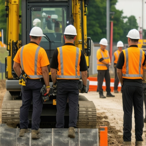
In 2024, the construction and site prep world is more complex than ever. Urban areas are crowded with underground utilities, many of which are undocumented or outdated. The risk isn’t just damaging infrastructure; it’s safety, project delays, and hefty fines. That’s why trusted vacuum excavation combined with utility mapping is transforming how we approach site access. These technologies allow us to see what’s beneath the surface before we dig, reducing surprises and ensuring everyone stays safe.
Is This Technology Really Worth the Investment?
I used to think that spending extra on advanced site services was an unnecessary expense. My early mistake was underestimating how costly an accident can be — both financially and in human terms. When I finally adopted vacuum excavation and precise utility mapping, I saw immediate benefits: faster project start times, fewer accidents, and peace of mind. Trust me, the safety and efficiency gains are well worth the initial investment.
For a deeper understanding of how modern solutions like vacuum excavation work, check out this comprehensive guide. It’s a game-changer for anyone serious about safer site access.
If you’re still hesitant, ask yourself: have you ever faced costly delays or safety scares because you skipped proper subsurface assessment? If yes, then it’s time to rethink your approach. Embracing these innovative methods in 2024 isn’t just smart — it’s vital for a safer, more reliable project timeline. Now, let’s look at how to implement these tools effectively and avoid the pitfalls I once fell into.
Map Out Underground Obstacles Before You Dig
Start with comprehensive site assessment using advanced vacuum excavation techniques. I recall a project where I arrived on site ready to begin, only to find a tangled maze of outdated utility lines. By applying vacuum excavation to carefully expose utilities, I avoided costly delays and safety hazards. This method allows you to gently excavate without damaging existing infrastructure, making it the backbone of safe site prep.
Use Precise Utility Mapping for Clarity
Next, leverage precise utility mapping tools. These systems create accurate underground maps, helping you visualize what lies beneath. I once worked on a dense urban site where old maps showed conflicting information. Employing modern scanning and utility mapping techniques revealed hidden pipes and cables, preventing accidental strikes. Think of it as giving your project X-ray vision, so you can plan your excavation around existing utilities confidently.
Implement Daylighting for Critical Utilities
For high-risk areas, daylighting boreholes provides a clear view of underground utilities. I remember a project where daylighting uncovered a major gas line unexpectedly. The process involves creating visible boreholes that serve as safe access points for ongoing utility inspection. This real-time visibility reduces surprises and enhances safety. Integrate daylighting with borehole techniques to ensure reliable and safe construction.
Coordinate and Document Every Step
Document your findings meticulously. Use digital mapping and record every exposed utility, ensuring everyone on-site has access to up-to-date information. On a recent project, a well-maintained digital record saved us from re-excavating multiple times due to conflicting data. Consistent documentation minimizes risks and streamlines future operations.
Incorporate Safety-Driven Site Services
Finally, always use trusted site services to support your excavation strategy. These include specialized vacuum excavation teams, utility locating experts, and daylighting specialists. Their combined efforts create a layered safety approach, reducing the chances of accidents and ensuring project continuity. Remember, the goal of these methods isn’t just compliance but creating a safer environment for everyone involved.
Many professionals in the construction and site prep industry believe that simple utility maps or old records are enough to guide excavation projects. In reality, this is a dangerous misconception. Relying solely on outdated or incomplete maps is one of the most common pitfalls that can lead to costly damages, safety hazards, and project delays. The truth is, underground utility detection is far more nuanced than just consulting existing records.
One widespread myth is that utility maps are always accurate. While some utility companies maintain precise records, many underground utilities are undocumented, especially in urban areas where infrastructure has evolved over decades. According to a study published in the Journal of Construction Engineering and Management, up to 30% of underground utilities are either misplaced or entirely undocumented, leading to unexpected encounters during excavation. This means that even the best old maps can be misleading, increasing the risk of strikes.
Another misconception is that technology alone can replace site assessment. Many assume that high-tech solutions like ground-penetrating radar or electromagnetic scanners are foolproof. However, these tools are most effective when combined with physical methods such as vacuum excavation to verify utility locations before digging. Over-reliance on technology without ground-truthing can give a false sense of security. As explained in this resource, integrating these methods ensures accurate, safe results.
What advanced techniques can help avoid costly mistakes?
Implementing a layered approach that combines precise utility mapping with daylighting and vacuum excavation is the most reliable way to prevent surprises. Modern borehole and daylighting solutions can uncover utilities in real-time, giving you a clear picture of what’s beneath. This proactive approach not only enhances safety but also streamlines project timelines, reducing unforeseen delays and rework.
Remember, the key is not just technology but how you use it. Proper planning, thorough site assessments, and leveraging expert site services are crucial. If you want to deepen your understanding of these advanced methods, explore this comprehensive guide on vacuum excavation.
Have you ever fallen into this trap? Let me know in the comments. Addressing these myths head-on can save you time, money, and even lives on your next project.
Keeping the Equipment in Top Shape
When it comes to maintaining reliable utility mapping, the longevity of your tools is crucial. I personally rely on high-quality vacuum excavation units like the best vacuum excavators because they are built for durability and precision. Regular maintenance involves checking hydraulic lines, replacing filters, and calibrating sensors to ensure optimal performance. Don’t overlook routine inspections; a well-maintained machine reduces downtime and prevents costly breakdowns that can delay your projects.
Investing in the Right Software for Accuracy
Accurate data collection is just as important as physical tools. I recommend using advanced GIS (Geographic Information System) software integrated with utility mapping solutions. Software like ArcGIS or QGIS allows for layered data analysis, helping you visualize underground utilities with greater clarity. Consistent updates and training on these platforms enhance your team’s ability to interpret data correctly, leading to fewer surprises during excavation. Predictive analytics within these systems are advancing rapidly, promising even better long-term planning in the future.
How do I maintain consistency over time?
Establishing a routine maintenance schedule and investing in ongoing training are key. Regularly servicing your vacuum excavation units and updating your software ensures your team operates at peak efficiency. Additionally, documenting every project detail creates a valuable reference point, helping identify trends and areas for improvement. Over time, this disciplined approach reduces operational errors and maintains high safety standards.
Scaling Up for Larger Projects
As your project scope grows, so should your tools and strategies. Scaling requires investing in modular equipment that can adapt to various site conditions. For example, portable borehole drilling and daylighting systems can be added to your fleet, providing flexibility and expanding your capabilities. Partnering with trusted site services, like those detailed here, ensures you have expert support for complex projects. Forward-looking companies are now integrating IoT sensors into their equipment, enabling real-time monitoring and predictive maintenance, which minimizes downtime and maximizes efficiency.
Why Regular Upgrades Matter
Technology evolves rapidly, and staying current can give you a competitive edge. Upgrading to the latest vacuum excavation models and software updates ensures you benefit from improved accuracy and safety features. For instance, newer units often incorporate enhanced filtration systems that reduce environmental impact and improve working conditions. Embracing these advancements now positions you well for the future, where automation and AI-driven diagnostics will become standard.
Start by evaluating your current equipment and identifying areas where upgrades could boost performance. Implement a scheduled maintenance plan, and consider training your team on new technologies. This proactive approach not only extends your tools’ lifespan but also keeps your operations aligned with industry best practices, ultimately leading to safer, more reliable utility mapping in every project.
The Hardest Lesson I Learned About Utility Mapping
One of my most eye-opening experiences was realizing that relying solely on outdated utility maps can be a dangerous gamble. I once arrived on site confident in existing records, only to find a maze of undocumented pipes and cables. That mistake taught me the importance of verifying every detail physically, using modern vacuum excavation techniques. It’s a reminder that beneath every surface, there’s a story waiting to be uncovered, and skipping this step can cost dearly.
My Essential Toolkit for Safe Site Preparation
For anyone serious about underground utility detection, I recommend a combination of top-tier vacuum excavation units like the best vacuum excavators and advanced utility mapping software such as ArcGIS. These tools provide accuracy and reliability, reducing risks and streamlining workflows. Pairing physical verification with digital overlays has transformed my approach, ensuring every project starts on a solid, safe foundation.
Stay Ahead with Future-Ready Strategies
As the industry evolves, integrating IoT sensors into your equipment and adopting predictive maintenance practices can give you a competitive edge. Regularly upgrading your tools and software isn’t just about efficiency; it’s about safety and precision in every excavation. Continuous learning and adaptation are key to mastering underground site management in 2024 and beyond.
Your Turn to Try
Implementing these advanced utility mapping and vacuum excavation techniques can significantly improve your project outcomes. Don’t wait for costly surprises—start integrating these strategies today. Remember, safety and accuracy are investments that pay off in peace of mind and project success.
Have you ever faced a utility strike that could have been avoided? Share your story below—I’d love to hear how you tackled it!