Ever had that sinking feeling when you’re about to start digging and suddenly realize there’s a buried utility line just inches beneath the surface? It’s a nightmare that every construction pro has faced at some point. I remember my first project where I ignored proper utility mapping — it was a close call. Luckily, I learned a hard lesson early: rushing into excavation without the right prep can turn a smooth project into a dangerous mess.
Why Safety and Precision Matter in Modern Construction
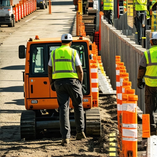
In today’s fast-paced construction world, safety isn’t just a box to check — it’s the foundation of every successful project. When you’re working around underground utilities, a single mistake can lead to costly delays, environmental harm, or even serious injuries. That’s why trusted vacuum excavation and utility mapping are game-changers. They help you see what’s beneath the surface with clarity, so you can plan your work confidently and avoid surprises.
Is this approach really worth the hype?
I used to think that traditional hand-digging or outdated methods were enough. But I quickly discovered that those methods are often unreliable and risky. Early on, I made the mistake of skipping detailed utility locating, which led to a halted project and a hefty repair bill. Since then, I’ve embraced advanced techniques like vacuum excavation, which is proven to minimize site disruption and maximize safety. Want to learn how to do the same? Keep reading, and I’ll walk you through the two essential steps to safer, more reliable site projects.
Start with Precise Utility Location
Before any digging begins, confirm the exact positions of underground utilities using advanced utility mapping techniques. I recall a project where we skipped detailed utility detection, leading to a costly repair and a week-long delay. To avoid this, I recommend investing in high-quality vacuum excavation — a modern solution for safe site prep — which allows you to accurately locate and expose utilities without risking damage. This process involves gentle suction to remove soil and reveal underground lines, providing a clear, real-time view of what lies beneath. For detailed insights, visit vacuum excavation benefits. This step ensures you understand the subsurface landscape, minimizing surprises during construction.
Use State-of-the-Art Equipment for Reliability
Choosing the right equipment can dramatically improve safety and efficiency. I once led a project where we used a combination of ground-penetrating radar and vacuum excavation to map utilities in a congested urban area. The results were impressive: precise location data, minimal site disruption, and no utility strikes. This approach is part of trusted vacuum excavation and utility mapping techniques. Consistent use of proven technology ensures your site plans are accurate and your team stays safe, especially when working close to critical infrastructure.
Implement Clear Communication and Documentation
After mapping, document all findings meticulously. I learned this the hard way on a project where incomplete records led to accidental utility strikes. To prevent this, create a detailed site plan integrating all utility locations, and communicate this plan clearly with your team. Use digital tools and visual markers to keep everyone on the same page. Regular updates and checks during excavation prevent costly mistakes and keep your project on track. For guidance on effective borehole and daylighting strategies that enhance service reliability and safety, check this resource. Documenting and sharing information ensures everyone understands the risks and safety protocols, making the entire process smoother and safer.
Final Tip: Collaborate with Experts
Partner with experienced site service providers specializing in vacuum excavation and utility mapping. Their expertise can turn a risky project into a safe, predictable operation. On a recent project, collaborating with a trusted team allowed us to identify hidden utilities early, avoiding delays and safety hazards. It’s a smart move to leverage their knowledge and equipment. For comprehensive support, reach out here. Remember, safety and precision aren’t just goals — they’re essential to your project’s success.
Many professionals believe that simply having basic utility plans is enough when starting an excavation project. However, this is a dangerous misconception. The real challenge lies in understanding the nuances of utility detection and the advanced mistakes that can compromise safety and project integrity. Let’s dig deeper into what most people get wrong about utility mapping and vacuum excavation, so you can avoid costly errors and delays.
Why Overconfidence in Old Data Can Lead to Disaster
One of the biggest myths is trusting outdated utility records without verification. In many cases, underground infrastructure has shifted or been added without proper documentation. Relying solely on old maps is a surefire way to cause utility strikes. Instead, always use vacuum excavation techniques to confirm exact locations physically. This approach minimizes the risk of unexpected utility encounters, especially in complex urban environments.
Are Standard Detection Methods Sufficient for Complex Sites?
Many assume that ground-penetrating radar (GPR) or electromagnetic locators alone are enough for precise utility detection. In my experience, combining these tools with vacuum excavation provides a higher accuracy rate. Relying on a single technology can leave blind spots, especially when utilities are closely spaced or poorly mapped. Advanced detection often involves a multi-tool approach, validated with physical exposure, which is key to avoiding the “oops” moments that lead to costly repairs.
The Hidden Danger of Ignoring Depth and Material Variability
Another common mistake is neglecting the depth and material differences of underground utilities. Many operators focus on horizontal location but forget that utilities can be at varying depths or made of different materials, affecting excavation strategies. For example, plastic pipes are less detectable than metallic ones, increasing the risk of accidental damage. To mitigate this, I recommend integrating daylighting strategies that allow for better visualization of subsurface conditions, especially in dense urban settings.
How Can Advanced Site Planning Improve Safety?
Advanced planning isn’t just about initial detection. It involves continuous updating of utility maps during excavation and employing innovative borehole techniques to verify utility positions as work progresses. This dynamic approach prevents surprises and keeps your project on schedule. Remember, even the most detailed initial survey can become outdated once excavation begins, so ongoing verification is essential.
Have you ever fallen into this trap? Let me know in the comments. Avoiding these advanced pitfalls will make your projects safer, more efficient, and less costly. For comprehensive support, always collaborate with experienced site service providers who understand the intricacies of utility detection and vacuum excavation. Your team’s safety and the success of your project depend on it.
Investing in Reliable Equipment for Consistent Results
One of my go-to tools for maintaining accuracy in utility detection is the Vermeer VXT400 vacuum excavator. I personally prefer this model because it combines powerful suction with precise control, allowing me to expose underground utilities safely without risking damage. Unlike older, less efficient models, the VXT400 offers adjustable vacuum pressure and integrated water spray systems, which are invaluable for minimizing soil disturbance and improving visibility. Additionally, investing in high-resolution vacuum excavation technology ensures your team operates with the latest safety standards and capabilities.
Streamlining Site Planning with Advanced Software
Beyond hardware, I recommend using specialized software like AutoCAD Civil 3D for detailed site modeling. This program allows me to integrate data from utility surveys seamlessly, creating accurate 3D models that help visualize subsurface conditions. It reduces guesswork during excavation and helps plan boreholes or daylighting strategies with confidence. The future of site planning is leaning toward integrated GIS and real-time data updates, which will further enhance accuracy and efficiency. To stay ahead, I suggest exploring the latest updates in these tools, as they can significantly improve your workflow.
How do I maintain these tools over time?
Regular maintenance is key to ensuring your equipment remains reliable. For vacuum excavators, this means routinely checking hoses, filters, and pump systems for wear and tear. I also schedule professional inspections and calibrations annually to keep everything in optimal condition. For software, keeping licenses up-to-date and performing regular data backups prevents unexpected issues. Remember, well-maintained tools not only extend their lifespan but also ensure consistent safety and accuracy during site work. Make it a habit to establish a maintenance schedule and stick to it diligently.
Finally, I encourage you to try integrating daylighting techniques into your planning. These methods provide additional visual confirmation of subsurface conditions and can be a game-changer for complex projects. As technology advances, staying informed and investing in the right tools will keep your projects running smoothly and safely. For expert support, don’t hesitate to reach out here.
Three Surprising Lessons That Changed My Approach to Safe Excavation
One of the biggest lessons I learned was that trusting outdated utility records is a recipe for disaster. I once relied on old maps only to find that underground infrastructure had shifted, causing a costly utility strike. Now, I always verify locations with vacuum excavation techniques. It’s a game-changer for accuracy and safety.
Why Combining Technologies Saves the Day
Initially, I believed that ground-penetrating radar alone was enough. After a few close calls, I realized that combining GPR with electromagnetic locators and physical soil removal via vacuum excavation provides a much clearer picture. It’s like having multiple layers of assurance that your site is safe to dig.
The Depth and Material Mystery
One overlooked detail is utility material and depth variability. Plastic pipes are harder to detect than metal ones, and utilities at different depths demand different strategies. Using daylighting strategies can help visualize these hidden differences, reducing surprises during excavation.
Partnering with Experts Is Non-Negotiable
I’ve learned that collaborating with experienced site service providers can make or break a project. Their expertise in utility detection and vacuum excavation ensures a safer, more reliable process. For support, I always recommend reaching out here — it’s worth it for peace of mind.
This article really hits the mark on the importance of accurate utility mapping and modern excavation techniques. I remember a project in downtown Seattle where we relied solely on outdated utility records, and it almost led to a mix-up with underground gas lines. Since then, I’ve seen firsthand how vacuum excavation combined with GPR can greatly reduce risk and save time. I’m curious, what are some common pitfalls when selecting equipment for utility detection? I’ve found that not all vacuums are created equal, and choosing the right model can make a huge difference in accuracy and safety. It would be great to hear some expert recommendations on equipment choices for urban environments, especially for complex sites with dense underground infrastructure.
This post highlights some crucial points that often get overlooked in the rush to start excavation. I especially agree with the emphasis on continuous verification—underground utilities can shift over time, and relying on outdated maps can lead to dangerous surprises. I’ve been involved in projects where integrating vacuum excavation with ground-penetrating radar and electromagnetic detection made all the difference in avoiding utility strikes. Personally, I find that combining these methods provides a more comprehensive picture of the subsurface conditions.
A challenge I often face is balancing thorough detection with project timelines. While advanced equipment and detailed planning are essential, they can sometimes extend the pre-excavation phases. How do others prioritize efficiency without compromising safety? In my experience, investing in reliable technology and collaborating closely with experienced utility detection teams usually pays off by preventing costly delays and safety hazards down the line.
This article really underscores the importance of proper utility mapping before jumping into excavation. From my experience working on urban construction sites, I’ve seen how even small oversights in utility detection can lead to major delays and safety hazards. Vacuum excavation has been a real game-changer for me—it’s incredible how gentle soil removal can prevent utility strikes and provide clear visuals of underground infrastructure. I’m curious, for those who have faced particularly complex underground conditions, what additional strategies or technologies have you found effective in ensuring accuracy? Do you combine multiple detection methods, or do you rely more heavily on certain tools depending on the site conditions? I think sharing real-world approaches can really help improve safety and efficiency across projects.
This post really resonates with my own experiences in construction safety. I recall a project where relying solely on old utility maps almost resulted in a costly mistake. Since adopting vacuum excavation combined with GPR and electromagnetic tools, we’ve significantly minimized utility strikes and delays. It’s clear that verifying subsurface conditions thoroughly upfront can save a lot of trouble later. I’ve noticed that smaller contractors often overlook the importance of advanced detection technology due to budget constraints, but in complex urban projects, the investment really pays off. Have others found that using a multi-tool detection approach is always necessary in dense environments, or are there specific signals to look for that indicate when one method might suffice?
Also, I’d like to hear thoughts on how to best integrate these technologies into existing project workflows without causing significant bottlenecks. Balancing thorough detection with tight schedules can be challenging, but safety should always come first. Thanks for emphasizing these crucial steps—safety and precision are definitely non-negotiable.